How can we have “global warming” and still have monster snow storms and frigid winters? Somehow that never made sense to me, until one day I stumbled upon the answer contained in an insurance company report from Swiss Re, that had written a report a few years ago about how climate change effects insurance payouts. (Update. the original report is over five years old and no longer on their site, but the link takes you to their climate risk page).
Swiss Re is a “reinsurance” company that insures other insurance companies. “Reality-based” organizations, like the U.S. military, or large insurance corporations that pay out millions of dollars of claims money, tend to focus on evidence, cost versus benefit, and their bottom line. They’re really good at getting to the heart of matters.
(Cover image from cbs7.com)
A Quick Explanation
The Swiss Re report described how warming of the climate causes air at the equator to heat up more than usual and hold more moisture. Warm, moist air rises at the equator and sinks at the poles, like it always has.
However, more heat and more moisture causes these circulating air masses, called Hadley Cells, to push farther north before sinking down. This pushes back the front that keeps cold Arctic air in the North. A “front”, of course, is just the place where two big air masses with different temperatures meet.

So now with the Polar Front pushed further North, weather patterns moving west to east across the U.S. slow down, pick up more moisture — drying the land in one place — then dumping that moisture downwind creating epic snow or rain storms in another place. That’s a simple explanation in a nutshell.
Since the SwissRE report was released, climate scientists have been trying to better understand how changes in Arctic atmospheric circulation creates extreme weather. They have several promising theories, which we’ll get into below.
Although the exact mechanism is still under investigation, one thing is certain, the Arctic is warming at over twice the rate of the rest of the world. You can see that in the map below which shows actual temperature changes over the whole globe. (Of note, this warming trend was predicted by every climate model to date!)


The Gory Details
An excellent review article from the journal Nature Geoscience titled “Recent Arctic amplification and extreme mid-latitude weather” will help shed some light on extreme winters in the mid-lattitudes. The mid-latitudes are above the equator and below the Arctic Circle, which is where most of the U.S., Europe, and Russia are located.
(Update: This article is 5 years old now, and some of the particulars have changed, but overall it’s still one of the best summaries I have seen.)
The authors state that the Arctic ice “… is sensitive to variations in the poleward transport of heat and moisture into the Arctic from lower latitudes”; just as described by the SwissRE report (the big Hadley Cells moving heat and moisture North from the tropics).
They also say that the “September sea ice has declined at a rate of 12.4% per decade since 1979, so that by summer 2012, nearly half of the (summer) areal coverage had disappeared. This decrease in ice extent has been accompanied by an approximately 1.8m (40%) decrease in mean winter ice thickness since 1980 and a 75-80% loss in volume.”
As a result of the warming and the melting there is more ice-free ocean during the Arctic summer, so the exposed ocean absorbs more heat from the atmosphere than before.

As the Arctic winter approaches, the heat absorbed by the ocean radiates back into the atmosphere. This is “Arctic amplification”, and it results in a bunch of weird weather effects. So how does a warming Arctic and “Arctic amplification” result in extreme winter weather in the mid-latitudes?
The exact way in which changes in the Arctic affect the weather down here in the mid-latitudes, where many of us live, is not known for sure. However, there are three main ideas under investigation, including…
- changes in storm tracks
- changes in the Jet Stream
- changes in large waves in the high atmosphere
Any or some combination of these mechanisms can result in extreme winter weather at lower latitudes.

A bit of background first…
The way storm fronts move across eastern North America are often affected by two big features in the atmosphere over the North Atlantic Ocean and the Arctic. These features are the North Atlantic Oscillation and the Arctic Oscillation. Fancy terms for big areas of pressure change and atmospheric circulation that generally hang out over the same place.
North Atlantic Oscillation (NAO)
The NAO refers to a large center of low pressure over Iceland (the white shaded area in the figure to the right), and a complementary center of high pressure to the south over the Azores (blue shaded area). Low pressure generally means that warmer air is rising into the upper atmosphere, while high pressure indicates colder air sinking down from the upper atmosphere.
When the NAO is strong (positive), cold air is pulled off of North America, making winters warmer. You can think of it as a giant vacuum cleaner set on high, sucking cold air off of North America. When the NAO is weak (negative), the opposite is true, cold air backs up over the eastern U.S., which also keeps temperatures lower in the midwest and the southeast. Or in other words, the vacuum is set on low so it doesn’t suck up as much cold air.
Arctic Oscillation (AO)
The AO refers to a big atmospheric circulation system that lives over the Arctic and controls the Polar Vortex, a huge pressure system that hangs out over the North Pole.
Just like the NAO, the AO is either strong or weak. When the pressure is very low and the upper atmosphere is very cold, the NAO and the Polar Vortex are strong, making west to east moving winds in the upper atmosphere called the Westerlies go fast — which traps the cold Arctic air where it belongs, in the Arctic.
The AO is strongest when the upper atmosphere, the Stratosphere, is coldest. When the Stratosphere is not as cold as usual, the AO weaker, which makes the Polar Vortex weak. When the Polar Vortex is weak the Westerlies slow down.
When the Westerlies slow down cold Arctic air spills down across the midwest and northeast U.S., as shown in the figure below. Both the NAO and AO are weakened by the northward movement of warm moist air by the Hadley Cells.
Now here’s where global warming comes into it…
Now we return to the three possible ways that global warming can affect Arctic atmospheric circulation, and lead to extreme, mid-latitude winters in the U.S. and elsewhere. As discussed above, warmer Arctic summers due to global warming lead to less and less sea ice during the Arctic summer. Less ice means more open water. Open water means that the ocean both soaks up more summer heat, and then radiates it back into the atmosphere at the end of summer. And… more heat means more energy to add more moisture to the air.
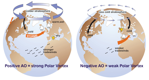
1. Changes in Storm Tracks
Warmer Arctic air picks up more moisture from the increasingly ice-free ocean at the end of the Arctic summer. More moisture causes more snow cover to form across northern Europe and Asia at the start of winter, which weakens the NAO, causing cold air to back up over the eastern U.S. Furthermore, warmer Arctic air also weakens the AO, which weakens the Polar Vortex, slows the Westerlies, and causes cold arctic air to spill south to the mid-latitudes (the globe on the right in the image below).
So if you have cold arctic air spilling south due to a weakened AO/Polar Vortex, and slow-moving weather systems due to a weaker NAO, what do you get? More monster snow storms and Arctic temperatures dipping far south into the US.
2. Changes in the Jet Stream
The second possibility is that the Jet Stream is thrown out of whack by warming Arctic air.
The difference in temperature between the Arctic and mid-latitude atmosphere is what drives the Jet Stream. When the temperature difference between north and south is high, the Jet Stream is strong and fast, and tends to flow in a more direct, straighter path across the northern U.S. and Canada, which helps keep cold Arctic air trapped in the Arctic. But, because of Arctic warming the difference in temperature between north and south is decreased, so the Jet Stream slows down.
When the Jet Stream slows down, it tends to meander like a lazy river, dipping south more often. A slow-moving, meandering Jet Stream pushes cold Arctic air south, causing extreme cold. Combine this with slow moving storm fronts that suck up more moisture, you get more extreme dumps of rain and snow than usual.
3. Planetary Waves
Modification of Rossby Waves over Europe and northern Asia is another way to make mid-latitude winters worse. Rossby Waves, according to Google, are “also known as planetary waves, are a natural phenomena in the atmosphere and oceans of planets that largely owe their properties to rotation (of the Earth)… Atmospheric Rossby waves on Earth are giant meanders in high-altitude winds with major influence on weather.”
Less sea ice forms in the Arctic Barents and Kara seas in the Autumn season due to prolonged summer warming. This allows more heat and moisture into the atmosphere, leading to more early snow storms in northern Europe and Asia, as discussed above. Either the increased storm activity or the added snow-cover over northern Europe and Asia, causes disruption of the lower atmosphere. This disruption puts energy into the upper atmosphere, warming it, which changes the structure of Rossby Waves.
The altered Rossby Waves in the upper atmosphere end up weakening the Polar Vortex. And, as you recall, a weaker Polar Vortex results in weaker Westerlies, and more cold air spilling down from the Arctic into the middle latitudes.
To bring it home…
The authors state that although some of these explanations have gained popularity in the media, study of these different phenomena suffer from “…lack of statistical significance, causality unclear, (and) incomplete mechanistic understanding….” In other words, what they are saying is that “we don’t completely understand it yet, but we’re working on it.”
The authors close by saying that “Dramatic changes are occurring in the Arctic climate system, and at the same time, the frequency of mid-latitude extreme weather events appears to have increased.”
They also state that this area of investigation is critically important because Arctic warming “is robustly predicted to continue over the coming decades.” Again, in other words, “it’s getting worse, so we really need to understand it.”
So, while we may not know the fine points of what’s causing the increase in severe winter weather, one thing is for sure, it’s going to continue. As we continue to pump billions of tons of carbon dioxide into the atmosphere every year, we are running one big experiment on the planet. The probable outcome of our atmospheric experiment is that the Earth becomes an unpleasant place for humans to live, in the summer AND in the winter.
In sum…
- Arctic warming is happening at twice the rate of the rest of the world
- A warming Arctic is affecting large-scale atmospheric circulation
- Changes in large-scale atmospheric circulation cause extreme winter storms across the U.S. and Eurasia
- This will be the new normal, unless we get serious about reducing carbon pollution
(This post did not even touch on the southern half of the world and the Antarctic, but similar forces are in play there!)
If you want to read more about this topic, here is a link to a recent article by Marshall Shepard, who is a PhD meteorologist and an excellent climate communicator. This article also links to many other informative websites and articles… 3 Things People Get Wrong About The Polar Vortex And Climate Change
Last, but not least, here are a few more articles from this blog about extreme winter weather…
- Who Survives Extreme Winter Storms?
- A Climate Prepper’s Guide To Surviving Extreme Cold and Winter Storms!
This post was updated 16 March 2021.